Middlesbrough's Transporter Bridge is 100 years old.
The structure was officially opened on 17 October 1911 by Prince Arthur of Connaught. Designed by Darlington-based Cleveland Bridge & Engineering Co, the bridge cost £87,316 to build. The Grade II-listed Transporter Bridge, linking Middlesbrough and Port Clarence, is one of only six of its type still operating in the world and the only one in England. At its peak in 1919, 5.1 million pedestrians crossed the bridge, compared to just 16,000 (and 120,000 vehicles) in 2010. Often threatened with closure in the past, it is now seen as Teesside's icon. The bridge has survived German bombing raids, been featured on TV and in films, and on the video and cover of the single High by the Lighthouse Family. The running of the bridge is funded by both Middlesbrough and Stockton councils. Motorists, it seems, are opting to use 100-year-old engineering rather than take the often jammed Tees flyover.
The bridge, which turns 100 on 17 October, is a sign of home to some, and a sign of great engineering to all. The giant blue steel structure joins Port Clarence to Middlesbrough across the River Tees, and although passengers are now on the up, they hit a low in 2006 when only 90,927 made use of the bridge. Now on the rise, more than 122,000 passengers have used the blue bridge's yellow gondola to cross the river in 2009. Pedestrians can even buy a ticket to walk across the top of the bridge. Those who do not have the stomach can board the gondola at one side of the river and be carried across to the other. Commuters form the traffic these days, with many shoppers and tourists using it during off peak periods. The bridge is not only a symbol of the industrial north, it has also far exceeded the working life envisaged by its designers when it opened to traffic in 1911.
Centenary celebrations included a concert, interactive light display and people bungee jumping off the bridge. The event spanned a total of two weeks and it wasn't until the penultimate night that I made the 30 minute journey down the A19 to grab some photographs before my chance had passed. I arrived at the site just after sundown, which was probably the best way to begin my visit as I captured a fine silhouette shot with the bright horizon positioned right behind the bridge. The Transporter shipped its last vehicle across the river shortly after six o' clock - my first shot captured the crossing, shown above (picture one). I got chatting to a Proffesional Photographer who'd travelled down from Newcastle to photograph the bridge. He told me the Transporter Bridge light show was due to begin at 7.30pm and seeing as it was only 6.15pm at this point I decided to nip off for something to eat and return later to catch the light show. Within fifteen minutes I found myself in a fish and chip shop at nearby Seaton Carew - no surprise there!
Belly full and back to Teesside via the many power stations en route. It was a bit nippy by this time but I was soon in position on the river bank and awaiting the light show. A few photographers had gathered with tripods nearby. At half-seven precise the light show began. Rotating spotlights covered almost every inch of the giant structure, producing a shimmering effect on the steel, in a similar way that water reflects on a subject during bright sunlight. It was quite spectacular! As the evening light subsided the job of photographing the bridge became more challenging. The bridge ends were almost impossible to see through the viewfinder, making composition a bit of a task and 'Tight crop' certainly wasn't in my plan. Gone was the deep blue sky, replaced by a muddy brown tone, but still offering a nice shot.
Approaching 8 bells and it was time for the off. Back up the A19 towards God's Country - BYE BYE SMOG!
Cheers, AC
Thursday, 27 October 2011
Thursday, 20 October 2011
Latrigg - The Lake District
Another fell walk...
It was back to the English Lake District once again for a one-night camping stint at Castlerigg Farm near Keswick. The day hadn't started very well as we witnessed a derby day defeat to Newcastle at the Stadium Of Light, Sunderland. The weather was the only good thing about the match - the sun was beating down and it was definately tee-shirt weather at the tail end of Summer. We were hoping for much of the same as we left Sunderland and headed across the A66 to begin our camping trip. We were half way there when the weather took a turn for the worst and grey clouds suddenly covered the region, which meant rain was almost certainly on its way. Upon arrival at the campsite we pitched the tent in no time while the rain drizzled down and Keswick was now under heavy dark cloud. And so the rain came...in bucket loads. After cooking a meal in the tent we headed off in the car and drove along the A66 towards Lake Bassenthwaite, but there was little or nothing to see in such poor weather so we headed back to Castlerigg Farm. Time passed quickly and before we knew it we were tucked up and heading towards a sleep. And sleep we did - the rain continued during the night, but as dawn broke the place had faired up dramatically and we made plans to go fell walking whilst tucking into a nice fried breakfast. The plan was to tackle Latrigg, a modest climb of just over 1200 feet.
Latrigg is one of the lowest fells in the Lake District, but is a popular climb due to its convenient location overlooking the town of Keswick and the excellent views down the valley of Borrowdale from the summit. It is the least mountainous of the Skiddaw fells, the summit being almost entirely devoid of rock. The slopes of Latrigg are partially wooded, and logging work is currently being undertaken. One lone tree just south of the summit is prominently viewed in silhouette when approaching Keswick from the west along the A66. Commonly Latrigg is ascended from Keswick, the route beginning along Spooney Green Lane near the old railway station and then either making direct for the top or swinging north via Mallen Dodd. Threlkeld is another starting point, first crossing the Glenderaterra Beck and then climbing up the east ridge. The easiest way is to park at the end of Gale Road, from where the summit is a simple 10 minute stroll on grass, the most accessible of all the 214 Wainwrights. This car park is commonly used as the starting point for the ascent of Skiddaw, although the purist will first climb Latrigg from Keswick before setting foot upon its parent. A recently constructed path allows disabled access to the summit of Latrigg from the car park.
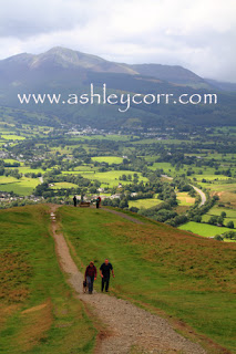
This was my sons first fell walk and he was very much looking foward to it. Latrigg was the ideal introduction for a ten year old, so off we went. It took us around 90 minutes to reach the summit from ground level, which wasn't bad at all even though we only stopped for drinks and a rest on two occasions. The first half of the walk was under blue sky with a scattering of broken clouds, but the second part was quite different as the sky clouded over and the wind crept up on us. Just short of the summit was a wooden bench that was sited in a perfect spot on the edge of the peak, overlooking the town of Keswick, and Derwentwater in the distance. On a better day the views would have been quite impressive, but today the light was poor and I quickly got the feeling that I would have to return another day to get the full benefit of the panoramic views from Latrigg, especially if I wanted to photograph it in all its glory. And that's what I intend to do, one day. All round the walk the views are of the surrounding fells are great, especially the ones of the Skiddaw Range. It made me feel like climbing it there and then but that was a non-starter, especially with my ten year old camping partner at my side. Today this was a very short, very easy walk to the summit of Latrigg, the small mountain that looks over Keswick. A blessed job.
Until the next time...
AC
Labels:
castlerigg,
derwentwater,
fell walk,
keswick,
lake district,
latrigg,
summit
Sunday, 2 October 2011
Whitley Bay Sunrise
It's been a few months since I captured my last sunrise shots, so with those very early Summer starts out of the way it seemed like as good a time as any to get back into it. From October onwards you can catch a good sunrise at a sensible time where you're not setting the alarm clock between 3 and 4am - the silly hours! Mind you, when you have the option of lying in a warm comfy bed, versus getting out of it on a freezing cold winter morning to take sunrise shots, well...some folk might say it's a 'No brainer'. But, anyone who's done sunrise before will tell you there's only one way to get those nice 'Crack of dawn' shots, and that is to get out there bright and early and do the necessary. Any dedicated photographer would not think twice about an early rise if he or she thought there was a good chance of bagging some good sunrise shots, and that's where I'm at these days, the alarm clock is only 'Enemy' on work days, he he (wink). That said, there's been a few times when I've turned out and there's been no sunrise to be had. Low cloud cover often kills the opportunity stone dead, so best do your homework the night before. I always check the weather forecast, sunrise times and tide tables so I can plan where I intend to visit the following morning, based on the information gathered.
Today I visited St. Mary's Island near Whitley Bay on the Northumberland Coast. This is a very photogenic part of the North-East coast and one that I've visited a handful of times in the past. The lighthouse is the focal part of this location and it dominates the stretch of coastline and can be seen from many miles away. The lighthouse is accessible via a causeway when the tide is low, but cut off once the tide returns. The rocks around the lighthouse are a minefield if you aren't wearing appropriate footwear at low tide, but on the plus side they come in handy when you're after some foreground interest. I came equipped with me wellies so I had no problems in that department. So, all I was waiting for was a good sunrise. The key to a good shot lies in the actual sunrise itself and the colours it presents, not only as the sun rises, but during that fifteen minute window beforehand. I was set up and raring to go, working with the following equipment...
Canon 7D body
18-135mm EF-S lens
Manfrotto tripod
Manfrotto ball & head grip
Lee foundation kit
Lee soft graduated ND filters, 0.3, 0.6, 0.9
Wireless remote control unit
(oh, and a Snickers bar!)
The first shot I took was captured shortly before sunrise. Taking my base exposure from the foreground sand, I then took a reading from the brightest part of the sky and made a mental note of the difference in f-stops. I knew that no compensation for the difference would burn out the detail in the sky completely, so out came the filters. I attached the filter holder to begin with, using a 67mm adaptor ring and screwing it into the lens thread. Then the filters came into play as I dropped in a combination of 0.9 and 0.6 Neutral Density grads. A quick test shot gave me the result I was waiting for - this is the actual test shot (above, shot 1). Both filters were positioned just above the horizon to hold back the detail in the sky. It worked quite nicely.
My second shot was taken a few minutes after sunrise - this was from a different spot, further back near the ageing wooden groynes that head out to sea. This is where those wellies came in handy as I was more than ankle-deep in sea water - something that the other photographers nearby never had the privelege of. Slippery seaweed lay underfoot at almost every step, so I was more than aware that falling flat on my arse was more than a possibilty as I negotiated the rocks in search of more angles to shoot from. My final viewpoint was right back off the rocky foreshore, next to the wooden groynes. The fractured rocks in front of me drew me instantly into my next shot. By this time the sun had been up around 15 minutes so the light had changed dramatically since my arrival at 6am. The 0.9 grad was removed and I was now running with only the 0.6 as the foreground base exposure was much lighter due to the sun hitting the rocks directly in front of me. This composition took in everything that was on offer - I quite like this one, although once again there was another shift in detail where the sky is concerned. Not much in the way of colour, just a bland greyish sky with highlights to the far right. The foreground makes up for this though in a busy kind of way. It wasn't long before I called it a day and went back to he car where a nice flask of coffee was waiting for me. I sat guzzling away in an attempt to warm myself up whilst listening to Smooth Radio before heading back home via the Tyne Tunnel. And so, my first sunrise shots for over six months and now, with the addition of my new Lee Filters, I'm looking forward to lots more early rises to improve my technique in this kind of photography. I'm already planning a visit to Bamburgh Castle, further up the Northumberland coast, probably around late October 2011. Until then I'll leave you with these three shots, which are hopefully just the start of a new collection of sunrise photography that will only get better.
Throws down the gauntlet...
Thanks for visiting.
Ash
Labels:
lighthouse,
northumberland,
sea,
seascape,
st marys lighthouse,
whitley bay
Angel Of The North, Gateshead
Static objects like the Angel Of The North are very straightforward subjects to photograph. As always, the light controls the conditions and the photographer controls exposure. A combination of correctness in both areas can yield a great final image, and although there's no such thing as 'correct' weather, as this is entirely open to interpretation based on the type of efffect you wish to achieve. There's no effects in these images though - they are simple daylight shots with plenty of colour under ideal summer weather conditions. As always, I try to include people in my Angel shots to give a sense of scale - The Angel Of The North rises 70 feet, but to anyone who hasn't seen the sculpure up close they obviously don't know the sheer size of it, hence the addition of people as extra's. I shot this first image from an angle that I previously hadn't attempted - crouching low under bushes in a small wasteland near the perimeter path. An overhang of leaves at the top, and grass sprouting from the bottom, frames the Angel quite nicely. There was a lot of broken cloud which sheltered the sun from the Angel every few seconds, so I had to act sharp and release the shutter precisely as the sun shone through, bringing out the natural rusty colour in my subject.
After switching postion to the far side of the Angel I heard voices nearby. People were walking up the path and into my shot - time to add that sense of scale - My second shot shows what I'm talking about. I waited a while longer, hoping more people would come along and lend themselves to my shots, but no-one showed up. Once again I heard voices and got myself ready for some more photography, but this time I got more than I bargained for. A coach load of German tourists had arrived at the site and within a few seconds the place was flooded with them, but this was no good to me, the shot would have been far too busy with that lot in frame. No thanks. Hoards of camera's were clicking away as I packed up my camera and made my way back to the car park. They seemed to be enjoying their experience so who was I to complain, eh. The 'Jormans' have landed!!!
My third shot was taken later that day when I returned to the site after a brief visit to Newcastle. Once again I waited for human intervention, which came in the shape of a mother with young child. The mother disappeared behind the legs of the Angel, leaving the youngster as an extra in my shot once again - now that's what I call scale! The only filtration used on each shot was a 67mm Circular Polarizer (Hoya Pro-1 Digital), rotated accordingly for maximum effect on the sky. All shots were taken handheld, on 'Shutter Speed Priority' (1/30th), using an ISO setting of 100. My trusty old 7D rig done the necessary once again. Can't be without it these days - it's a breeze to work with!
Coming next - Whitley Bay Sunrise - getting to grips with my brand new set of Lee filters.
Cheers, Ash
Tuesday, 27 September 2011
Herrington Country Park, Sunderland
A former Durham pit site, which was reclaimed and developed into the now known Herrington Country Park, the park is one of the largest in Sunderland and is home to a large selection of events including the Annual County Show, Marie Curie daffodil walk, diabetes UK walk in the park and many more. The park has cycle routes, boating lake, cycle/skate park, large amphitheatre created from grassed embankments and numerous sculptures/art works set out around the park. Herrington Country Park was once the site of Herrington Colliery, which closed in 1985. By that time the colliery waste heap was the largest in the North East and cast in the shadow of Penshaw monument, it was transformed into one of the premier parks of the North East.
A typical summers day presented me with an ideal opportunity to take some shots of the park from nearby Penshaw Hill. This vantage point was ideal as I had the bright sun behind me, bathing the park in light for long spells due to the sparse scattering of clouds. My first shot was taken between two pillars of Penshaw Monument as I faced south towards the park. A shadow of the Monument was cast across the grass embankment in front of where I stood, which was an ideal subject to fill the foreground, which would have been fairly bland without sun and shadow. This shot only shows a small section of Herrington Country Park, which lies to the right of the pond which is seen in the distance. Farm fields make up the bulk of this landscape shot and these are situated between the park and Offerton, just off the A183 single carraigeway. My second shot shows a larger section of the park although this, in fairness, is only a quarter of the actual size of the park. I was drawn to the landscape in front of me when composing the shot, opting not to pan too far to the right where the bright sun was 'Burning out' the sky. Once again, both shots were taken on a Canon 7D with a 18-135mm EF lens. A circular polarizer gave a nice effect to the cloud formation, adding some saturation to the blue sky in the process. The polarizer is a must for landscape shots - mine being a 67mm HOYA PRO 1-DIGITAL affair, picked up on ebay as a used item, but mint condition nevertheless. If you've just bought your first DSLR and fancy knocking out a few landscape shots (Ross!), then give one of these filters a try, they're worth shelling out for.
I'll be back soon. I'm trying to catch up on a backlog of blog images for you, including more low-light work in the shape of a Whitley Bay Sunrise, Latrigg Fell Walk in the English Lake District, Sunrise over Keswick and a few Angel Of The North shots. Until then...
Ash
Monday, 26 September 2011
Another Fell Walk - Catbells, English Lake District
After an enjoyable fell walking debut (Blencathra) in the English Lake District, I was more than keen to visit the National Park for another visit to the fells. During our recent 'Blencathra Weekender' I made a mental note of the position of the sun during different times of the day, keeping in mind the best area's of the Northern Fells where the sun would be behind me. My photography rarely involves shooting into the sun during the day - I only attempt this type of shot at dawn or dusk, so an idea of what I wanted was quickly forming in my head. I wanted some 'Big Shots', broken cloud, blue sky, fells bathed in sunshine, a lake or two - not asking for much is it? Naturally I followed the weather forecast during the days leading up to my visit, even though the Lake District weather can be very unpredicable and changeable to say the least. I was to make this trip on my own - no family, no friends, no workmates, just me. I find this tactic works best for photography - total focus, no distractions. I made the trip West along the A66 once again, a route I've become very familiar with lately. My homework was done and I'd selected another of the Northern Fells for my second climb - Catbells, a simple ascent with rewarding views across Derwentwater towards Blencathra and Skiddaw towards the Solway Firth - on a clear day of course. And a clear day was what I had. I arrived at Keswick mid-day, then made the twenty-minute journey via Portinscale to Catbells, parking in a nearby field for the sum of 'Three Squid'. With no OS map to follow I figured that the old-fashioned 'Follow The Sheep' tactic should do the trick. With camera in the backpack and drinks onboard it was time to leave the motor behind and begin the trek to the top.
From the makeshift car park I headed up a slight incline and over the cattle grid, which brought me to my starting point. According to the research I'd done the day before, an 'Obvious zig-zag path' is where I should have started my ascent up Catbells, but it wasn't so obvious to me - I missed the bugger completely! Obvious path? What Obvious path? Ah well, I found myself walking along a straight path along the bottom of the fell, just above the road, which I later learned was the 'Allerdale Ramble'. As I walked further it was clear to me that I was heading away from the Catbells summit and towards the nearby peak of High Spy, which is joined to Catbells at the top via Maiden Moor. Between the two peaks, along the Allerdale Ramble I noticed a very steep path to the top, so off I went, stopping to take a few photographs at more than regular intervals. The first shot (above) was taken where the Allerdale Ramble meets the steep path that I chose to climb - a panoramic effort looking over Derwentwater towards Blencathra. The second shot (shown here), and undoubtedly my favourite of the visit, was taken on the approach to the first scramble on High Spy. I remember stopping for a short breather before beginning the scramble, looking behind me along the Maiden Moor ridge. It was an excellent view, offering just about everything I'd visualised in my head a couple of days earlier. There was even a couple of fell walkers in the frame, finishing off a spectacular view. No point in admiring it for too long though - time to transfer this landscape vista to Compact Flash!
After negotiating a very straightforward scramble on High Spy I paused for a few more shots across the Newlands Valley. Another viewpoint that offered plenty in the way of landscape.
Sheep sat around me as I ran off a few frames. They appeared totally at ease in my company, which is not surprising considering the volume of people that cross their path on a daily basis. Mind you, with the wind creeping up and a steep drop below, I wasn't hanging around for too long so I scrambled up the final outcrop to the summit, where at least 20 people had already gathered. It was blowing a gale up top. A young lad was entertaining folk
by riding a monoclycle on the rocky summit. The entertainment value lay in the fact that he couldn't even perch his arse on the seat before being blown to one side, at least six times. He gave up eventually. Top marks for effort though.
After spending 20 minutes or so on the summit of High Spy, I made my way back down to Maiden Moor via the double rock scramble I had managed earlier. Once on the Moor I took the path that lead me along towards Catbells summit. More excellent views across Derwentwater and Bassenthwaite towards the Solway Firth in a North-Westerly direction. The sun had gone behind large clouds by this time, offering very little to no sunlight on the surrounding fells. Causey Pike stood to my left, looking every bit the next mountain on my list. Surprising how cold it gets up top when the sun goes in. I chatted to an American couple on the Catbells summit before reaching another rock scramble on the way down to the car park. They struggled with the scramble but I wasn't ready to hang around as the sun disappeared completely behind more cloud. Once over the rocks I paused to get my bearings, amazed at how tiny the cars looked in the field below, even though I was almost half way down the hill and now walking a zig-zag path. Ohhhh, so this is the zig-zag path I was supposed to follow on the way up !!! Ah well, better to be going down it than climbing up - it was a nightmare on the old joints! Two hours after leaving the car, I was back. By this time the sun had re-appeared and at ground level the heat was sweltering. Time to sit and take a well earned breather. Cool bag came out of the boot - freezing cold Coca-Cola went down without touching the sides. Another enjoyable walk - stroke - climb - stroke - scramble.
And that was that. Job done. Second one ticked off the list.
A few days later I sent my Catbells shot (no. 2, above) to Tyne-Tees Television, who presented it on one of their daily weather bulletins. The video clip can now be viewed in the monitor below - press the arrow on the control panel to view the footage. Until the next time, cheers!
Ash
Labels:
catbells,
fells,
high spy,
keswick,
lake district,
lakeland,
newland valley
Friday, 23 September 2011
Lakes Weekender (Blencathra) - The Final Word
The Blencathra blog ends here with a last offering of photo's and stats from our Lakes Weekender. It was a very enjoyable weekend and although it got off to a wet and miserable start the weather couldn't have been any better from Saturday morning onwards. Sunday morning involved a drive to Threlkeld where we parked up and walked to Keswick - an eight mile round trip! We had Sunday lunch and downed some beer before we returned to the car and made our way home, via Alston, one the top ten motorists roads in Great Britain. On our return to work the following day we reflected on a great weekend and started to plan another trip to the Lake District. Now, some 3 months later, I can reveal that we will be returning to the great outdoors once again, to climb Skiddaw, the fourth highest mountain in the Lake District National Park. This will take place in mid-October, so stay tuned for another account of our Lakes Weekender Part 2, here on my blog page. To finish off I'd like to show you a few more photographs from a collection of over 300, all taken during our Blencathra trip. Here are a few stats too...
Until the next time,
Ash
Statistics:
Start: Scales Farm
Start (OS ref): NY343269
Map (1:25,000): OL5 English Lakes North East
Parking: Lay-by at side of A66
Distance: 7.7 miles (12.5 km)
Time: 4 hours
Difficulty: Very Hard
Climbing: 869 metres of ascent
Hazards: Grade 1 Scramble on Sharp Edge
Until the next time,
Ash
Statistics:
Start: Scales Farm
Start (OS ref): NY343269
Map (1:25,000): OL5 English Lakes North East
Parking: Lay-by at side of A66
Distance: 7.7 miles (12.5 km)
Time: 4 hours
Difficulty: Very Hard
Climbing: 869 metres of ascent
Hazards: Grade 1 Scramble on Sharp Edge
Labels:
blencathra,
fells,
lake district,
scales farm,
scramble,
sharp edge
Subscribe to:
Posts (Atom)